
Update from Cass County Emergency Management on July 28-29, 2023 severe weather response
Last Updated on July 29, 2023 by Cass County Emergency Management Agency
Over the evening of July 28 into the morning hours of July 29, 2023, Cass County Emergency Management Agency was in the field with a line of severe storms that impacted Cass and surrounding counties. Activation of personnel began at approximately 8 p.m. on on Friday, July 28 and the last unit cleared from response operations at 11:30 a.m. Saturday, July 29. Personnel monitored conditions, forwarded watches and warnings from the National Weather Service, and supported public works and utility companies clearing roads and restoring power.
During the first round of storms, which impacted the Twelve Mile Area and far Northeast Cass County after 8 p.m., multiple funnel clouds were observed in the Twelve Mile area, mostly north and East of the county line as the first round of storms passed thru. EMA personnel observed these systems and relayed information to the National Weather Service as well as neighboring county emergency management agencies. There were no touch downs (tornadoes) known to be confirmed from this first round of storms in our area. There were a few isolated areas of trees down and power lines down, which were resolved within a relatively short period of time.
The more impactful round of storms reached the county after 2 a.m. Personnel in the field observed horizontal rain and very high winds. There were numerous reports of trees and powerlines down around the county. Visibility on roadways was almost nonexistent in some areas. A Travel Advisory (Yellow) Status was issued due to reduced visibility, numerous issues spread over a wide area, and receipt of new calls for service faster than what public safety, works and utility crews could respond to. Travel status was returned to normal once field personnel caught up with calls, visibility improved and most roadways were reopened.
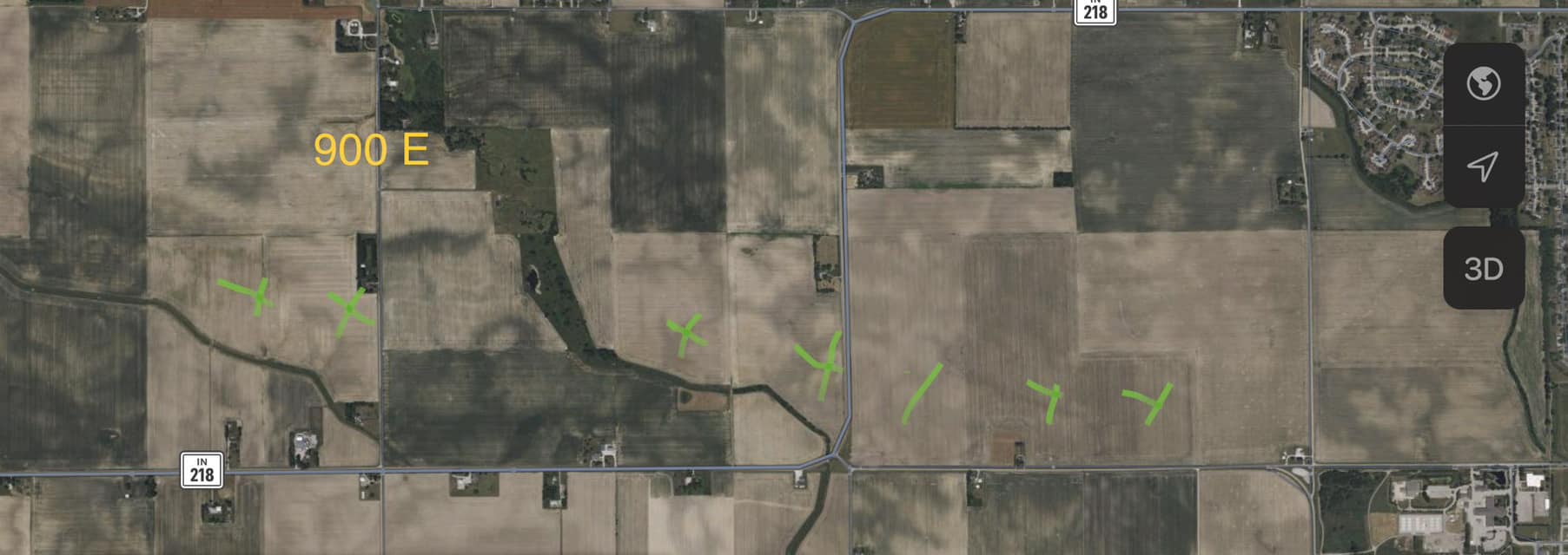
Personnel went back out later today to complete damage assessment and compile additional information. In the area of County Road 900 East North of State Road 218, extending east to the county line, drone pictures we were provided showed crop patterns consistent with a tornado touchdown. EMA personnel visited the area and gathered additional photographs and conducted interviews, and worked with the National Weather Service to process this information.
In speaking with the National Weather Service, confidence is high a weak tornado touched down in the farm fields in this area. As of press release time a rating has not yet been assigned. The current “EF-U” designation (undetermined) may be updated in a separate press release from National Weather Service once further analysis is completed. The National Weather Service also publishes the official confirmed track of tornadoes.
Prolonged power outages have been noted in the area, as well as some other spots of the county. EMA has reached out to social service agencies and power providers to see what services might be available for those impacted. Updates will be shared to the EMA Facebook page. Also on the EMA Facebook page is a list of links to area power providers, many of whom share maps that show outages and restore times in real time. Your local utility provider is the best source of information for updates regarding individuals residences and businesses.
EMA thanks those who worked outside in very difficult conditions overnight to reopen roads and restore power. We also thank the dispatchers who coordinated response behind the scenes during a period of very high call volume.
SOURCE: News release and photos from Cass County Emergency Management Agency